21stCenturyGIS Demo 1.0

Software brand for Remote Sensing, GIS, Terrain Modeling, Sub-Surface Mapping
3.7 
Rating
Your vote:
Latest version:
7.0 See all
Developer:
TWENTYFIRST CENTURY SOLUTIONS
Screenshots
1 / 1
Request
Download
link when available

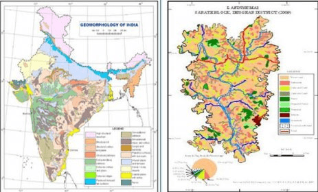
21st Century GIS the popular integrated software brand for Remote Sensing, GIS, Terrain Modeling, Sub-Surface Mapping and WebGIS. GIS Solutions: Digital conversion of map with data embedding, socio-economic survey, analysis and mapping, hydro-geological, investigation and feasibility mapping, environmental impact assessment and hazard zonation mapping. 21st Century GIS gives the power to process and interpret imagery, create map and analyze data in an easy way, understanding geographical relationships and developing decision support system.

Comments

3.7
Rating
9 votes
5 stars
5
4 stars
1
3 stars
0
2 stars
1
1 stars
2
User

Your vote:

Related software

GRASS GIS
GRASS GIS
Free
rating

Contains over 350 modules to render maps and images on monitor and paper.

Mapping & GIS License Manager
Free
rating

This program allows you to manage multiple licenses.

ASTEROID
ASTEROID
rating

Application designed for market research.

MapWindow GIS Lite
MapWindow GIS Lite
Free
rating

With this app you can visualize, edit, analyse data, and compose printable maps

Immortal Cities : Children of the Nile Demo
Immortal Cities : Children
rating

Build your own empire and become a leader of your virtual community.